Harper, Texas Weather Resources
Current Conditions & Forecast · Weather for Geeks · Aviation Weather
Online since 2012 · Weather archives dating back to 2009 · 1.6+ million weather observations
Weather for Geeks
Station telemetry, instrumentation, historical data and assorted atmospheric geekery
Station data updated:
04:25 PM · October 28, 2026
Atmospheric Parameters
Measurements and derived atmospheric values
Dew Point
63.7°F
Heat Index
78.7°F
Barometric Pressure
30.030 inHg
3-hour change -0.057 inHg
Wind
Current and short-term wind behavior
Current Wind
6 mph
S
(177°)
Current Gust
14 mph
S
10-Minute Average
7 mph
Average wind speed · last 10 minutes
10-Minute Peak
16 mph
Peak gust · last 10 minutes
Since Midnight
20 mph
Peak gust ·
02:20 PM
Past 24 Hours
20 mph
Peak gust ·
Oct 28 · 02:25 PM
Rainfall
Because every hundredth of an inch matters in the Hill Country
Today
0.00 in
Yesterday
0.00 in
Month
2.61 in
Year
27.31 in
Solar & UV
Solar radiation and ultraviolet observations
Solar Radiation
484 W/m²
Strong
Weak
Moderate
Strong
Very Strong
Intense
Current solar irradiance level
UV Index
2.8
—
Low
Moderate
High
Very High
Extreme
Sun exposure risk level
THSW Index
82.7°F
Calculated locally
Sun/wind impact on temperature:
+5.1°F
Sun & Moon Almanac
Solar and lunar events calculated for the Harper weather stationSun
Start Civil Twilight
07:23:21 AM
Sunrise
07:48:27 AM
Solar Noon
01:21:05 PM
Sunset
06:53:20 PM
End Civil Twilight
07:18:25 PM
Azimuth
232.3°
Altitude
27.9°
Declination
-13.3°
Next Equinox
03/20/2027 03:24:32 PM
Next Solstice
12/21/2026 02:49:59 PM
Moon
Moonrise
08:51:25 PM
Transit
03:16:19 AM
Moonset
10:42:36 AM
Azimuth
9.3°
Altitude
-32.9°
Declination
26.3°
Phase
Waning gibbous
Illumination
90% full
Next New Moon
11/09/2026 01:02:03 AM
Next Full Moon
11/24/2026 08:53:29 AM
Historical Weather
Harper station history, trends and climatological summaries
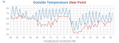
Temperature History
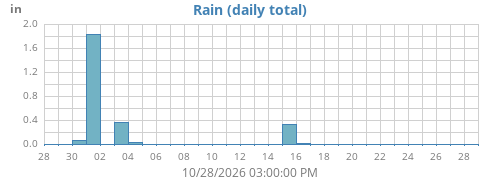
Rainfall History
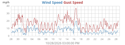
Wind History
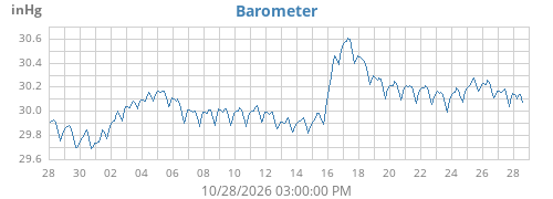
Pressure History
Station Records
Last checked: —
Highest Temperature
—
—
Lowest Temperature
—
—
Lowest Wind Chill
—
—
Highest Wind Gust
—
—
Highest Rain Rate
—
—
Wettest Day
—
—
Wettest Month
—
—
Wettest Year
—
—
Station records based on archived Harper weather observations.
Monthly Climatological Summaries
Daily temperature, rainfall, wind and degree-day observations
Reports are generated from the Harper WeeWX archive.
The current month's report is updated as new observations
are added to the database.
Current Year
YTD High
101.5°F
Aug 27, 2026
YTD Low
11.6°F
Jan 25, 2026
YTD Rain
27.31 in
Through Oct 28
Highest Wind
40 mph
Feb 14, 2026
2009-08
2009-09
2009-10
2009-11
2009-12
2010-01
2010-02
2010-03
2010-04
2010-05
2010-06
2010-07
2010-08
2010-09
2010-10
2010-11
2010-12
2011-01
2011-02
2011-03
2011-04
2011-05
2011-06
2011-07
2011-08
2011-09
2011-10
2011-11
2011-12
2012-01
2012-02
2012-03
2012-04
2012-05
2012-06
2012-07
2012-08
2012-09
2012-10
2012-11
2012-12
2013-01
2013-02
2013-03
2013-04
2013-05
2013-06
2013-07
2013-08
2013-09
2013-10
2013-11
2013-12
2014-01
2014-02
2014-03
2014-04
2014-05
2014-06
2014-07
2014-08
2014-09
2014-10
2014-11
2014-12
2015-01
2015-02
2015-03
2015-04
2015-05
2015-06
2015-07
2015-08
2015-09
2015-10
2015-11
2015-12
2016-01
2016-02
2016-03
2016-04
2016-05
2016-06
2016-07
2016-08
2016-09
2016-10
2016-11
2016-12
2017-01
2017-02
2017-03
2017-04
2017-05
2017-06
2017-07
2017-08
2017-09
2017-10
2017-11
2017-12
2018-01
2018-02
2018-03
2018-04
2018-05
2018-06
2018-07
2018-08
2018-09
2018-10
2018-11
2018-12
2019-01
2019-02
2019-03
2019-04
2019-05
2019-06
2019-07
2019-08
2019-09
2019-10
2019-11
2019-12
2020-01
2020-02
2020-03
2020-04
2020-05
2020-06
2020-07
2020-08
2020-09
2020-10
2020-11
2020-12
2021-01
2021-02
2021-03
2021-04
2021-05
2021-06
2021-07
2021-08
2021-09
2021-10
2021-11
2021-12
2022-01
2022-02
2022-03
2022-04
2022-05
2022-06
2022-07
2022-08
2022-09
2022-10
2022-11
2022-12
2023-01
2023-02
2023-03
2023-04
2023-05
2023-06
2023-07
2023-08
2023-09
2023-10
2023-11
2023-12
2024-01
2024-02
2024-03
2024-04
2024-05
2024-06
2024-07
2024-08
2024-09
2024-10
2024-11
2024-12
2025-01
2025-02
2025-03
2025-04
2025-05
2025-06
2025-07
2025-08
2025-09
2025-10
2025-11
2025-12
2026-01
2026-02
2026-03
2026-04
2026-05
2026-06
2026-07
2026-08
2026-09
2026-10
Climatological Report Archive
Select a month for the complete daily report
Loading climatological archive…
Earlier Years
Station & Instrumentation
The hardware behind the numbers
Weather Receiver
WeatherLink Live
Local network acquisition
Network Switch Temperature:
84.8°F
Network Switch Humidity:
35%
Wind
Davis Vantage Pro2
Transmitter 1
Battery: OK
Temperature / Humidity / Rain
Davis Vantage Pro2
Transmitter 2
Battery: OK
Weather Software
WeeWX 5.5.2
Harper weather server
Custom design by John Canfield
Coding assistance by ChatGPT
Custom design by John Canfield
Coding assistance by ChatGPT
Weather Oddities & Geek Calculations
Interesting numbers that nobody actually needs — which is precisely why they belong here
Weather Server Uptime
—
CPU Temperature
—
WeeWX Service Uptime
—
System Load
—
Disk Space Available
—
Last Weather Archive
—
Current Distance to Mars
—